I started riding my bike as part of my work commute in August 2002. The purpose was to increase the amount of exercise I was getting without significantly cutting into the amount of free time I have. With this goal in mind, I set about adapting my then-current daily commute to accommodate a bike ride a few times a week. At the time, my commute consisted of:
- Driving my truck to the nearest park-and-ride
- Boarding Max Light Rail (the train)
- Riding Max to within a block of my office
- Walking the remaining block to work
When I rode my bike two or three times a week, my commute changed to:
- Riding my bike to the nearest park-and-ride
- Parking my bike in a free bike locker
- Boarding Max Light Rail (the train)
- Riding Max to within a block of my office
- Walking the remaining block to work
On days that I drove, I showered at home. On days that I rode, I showered after I got to work (CPS has nice showers). That meant that I had to carry my clothes with me on mornings that I rode. Luckily, I have a nice set of bike bags that attach to the side of my bike rack in the rear. I got them for Christmas and didn't use them for years prior to this, but I'm sure glad I have them now!
After a few months of riding to the park-and-ride, I discovered that taking my bike on the Max was not as difficult as I had thought. Each train has either one or two cars. At least one of those cars will have four hooks, two on each end of the car, where one can hang a bike. And, as I'll explain below, my commute improved in several areas.

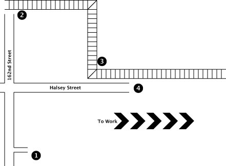
The first stage usually takes me from home to the Max. The figure to the right is a rough map of this stage. There are four major landmarks on the map:
- Home
- 162nd Street Max station
- Gateway Transit Center
- Start of Stage 2
Work is to the right, as the arrows indicate. The Max route is indicated by the train tracks. Halsey and 162nd are both main thoroughfares with bike lanes. The drawing is only meant to orient the reader and is not to scale nor should it be used to judge distances.
When I started riding, I would ride from home (1) up 162nd Avenue until I got to the Max tracks (2). At that point I would turn left and ride another 20 blocks to the park-and-ride at 182nd where my bike locker was. I would pull off my sweaty outer clothes, lock up my bike and carry my clean clothes onto the Max, boarding at 181st Avenue.
This was a challenging ride when I started. Although it's only about 3.3 miles, it took me about 20 minutes because the first half is all uphill. Specifically, the stretch of 162nd from our house to Halsey is a mild but long hill. By the time I pull up to the stoplight at Halsey, I'm already perspiring and breathing a bit heavier. This is not good because once I cross Halsey, I'm on the steepest hill I know and it goes up for about a block and a half. I have to drop to just about the lowest gear which means I have to pedal faster but go slower. When I started I could only climb that hill at about 5 mph. Now I can take it at up to 8 mph but usually choose to go a little slower. By comparison, my "cruising" speed on flat terrain is 18-20 mph.
After it started raining, I discovered a couple of things. First, my bike locker leaks which means the warm shirt and coat I would leave in it during the day would sometimes be wet when I picked them up at night. Second, I was not adequately equipped for riding in the rain. I was warm enough but I did not have waterproof clothing at all. By November, I started getting soaked on a regular basis. One day I decided I would shorten my ride on rain days by taking my bike on the Max with me. My ride was shorter because I could get on the Max at 162nd and wouldn't have to ride the extra 20 blocks to my locker. The shorter ride only takes about 13 minutes and is only 2 miles long.
I had initially feared that my Max ride would be considerably less enjoyable since I would have to stand with my bike for the 40 minute train ride. This would not only be uncomfortable but would make it virtually impossible to read, which I really enjoy. Fortunately, my preconceptions turned out to be unfounded. Tri-Met, the governmental body that runs public transportation, had begun installing bike hooks in the ground-level cars. Each train has at least one ground-level car, which guarantees that at least one car will have hooks installed. If one of the four hooks (two on each end of the car) is available, I can hang my bike, grab my book and sit down. Since 162nd is pretty far out, very few people have boarded yet so all four hooks are usually available. At first I found a few ground-level cars that had not yet had the hooks installed, but I haven't seen one of those for months now.
After I received rain gear for Christmas, I could once again extend my ride, rainy day or not. However, instead of riding away from work to my bike locker, I decided one day to try riding to the Gateway Transit Center (3). Although it was a longer route (5 miles), I would not have to ride up the steep hill that was on the other side of Halsey on 162nd. Although it takes me about 25 minutes to get to the Max via this route, the longer ride doesn't significantly lengthen my total commute time. Riding the Max from 162nd (2) to Gateway (3) takes about 10 minutes. Riding directly to Gateway takes only 12 minutes longer than riding to 162nd. So the longer ride only adds a couple minutes to my total commute time!
It gets better, though. Since two different Max lines, the regular line and the airport line, both go through Gateway, I double my chances of catching a train sooner than if I would board at the 162nd Street station, where only the regular line runs. So, although it's not easily quantifiable, riding to Gateway can actually decrease my total commute time.

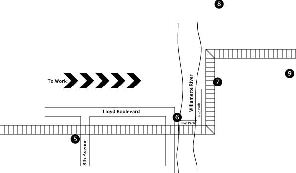
The second stage takes me the rest of the way to work. If I choose, I can forego the Max entirely and ride my bike the entire way (for a total of about 14 miles). On most mornings I'm not up for that long of a ride, so I "cheat" and take the Max from Gateway (about 102nd Avenue) until I get close to the Rose Garden, the arena where the Trailblazers play. The figure to the right is a rough map of my route after I get off the Max. There are five major landmarks on the map:
- NE 7th Avenue Max station
- Steel Bridge with Bike Bridge on the bottom
- Oak/SW 1st Avenue Max station
- Extensis Software
- Critical Path Software
Again, work is on the right side of the map as indicated by the arrows. The Max route is indicated by the train tracks. NE 8th and Lloyd Boulevard have bike lanes. The drawing is only meant to orient the reader and is not to scale nor should it be used to judge distances.
Before I started riding my bike, I would ride this entire stage on the Max. There are eight stops from 7th until Pioneer Square, which is two blocks from CPS. It takes the Max about a half an hour to get from 7th to Pioneer Square. Now that I'm working at Extensis, the closest Max stop is about 15 blocks away which leaves a long, uphill walk if I'm bikeless.
After I started taking my bike on the Max, I realized that I could ride this route faster than the Max could traverse it. I get off at NE 7th (5) and ride a couple of blocks to Lloyd Boulevard which is a really big hill that takes me around to a bike path (6) that crosses underneath the "Steel Bridge" (Portlander name). On the other side of the Willamette River, this bike path stretches along the waterfront about a mile and a half from the Steel Bridge to just past the Hawthorne Bridge. Now, I ride the whole length of the bike path since Extensis Software (8) is about 4 blocks past the Hawthorne Bridge. When I worked at CPS, I used to turn right at Oak Street and ride up eight blocks to Critical Path Software's office.
Of course, there are options along the way. If I get engrossed in my book or there is inclimate weather, I can ride to the Oak Max station (7) before getting off and riding the rest of the way to work. Most days I don't do that though, because it really isn't very much effort. It is downhill until you get on the bridge, flat until you get to Hawthorne and then only slightly uphill for a short stretch. There are only two stop lights at the beginning of this stage and two at the end. The bike path is very fast since there is no traffic other than fellow bikers and the occasional walker. It's also quite beautiful in the morning and afternoon.
On days when I have more energy or am less saddle sore, I may opt to ride all the way home or all the way to work without the aid of Max. Since I'm traveling almost 200 city blocks, there are a number of routes that I can take. Last Christmas I got a map of Portland that is made especially for bikers. The paper is coated to be weatherproof and the streets are color-coded to indicate bike-friendliness. It has alot of detail about the various bike-only trails that are all around Portland. It's also very handy for determining the safest, easiest route. Since I've been starting work early in the morning at Extensis, I've had several opportunities to take the long way home on some of these bike trails.
One is called Springwater Corridor. Because it's built on a former railroad corridor, it's very flat. It passed pretty close to our old house, so I used to ride on it pretty often back then. I only recently re-discovered it and was delighted to find that it had been lengthened and paved. It runs further south that I need to go to get home, but it's well worth the extra 6 miles it adds to the ride. It intersects with the I-205 bike path which I can take back up north to the Gateway Transit Center (see Stage 1 illustration).
The other major bike path that I have tried is the Marine Drive bike path that follows along the Columbia River. Although this path passes closer to our house, getting to it from downtown took me an hour the only time I tried it. It's a beautiful ride, but it is north of our house which means that I have to climb one of the giant hills to our house at the end of the ride. This psychological factor has served to discourage from trying this route again. Perhaps I should try it in the morning on the way to work.